
Table of Contents
Due to the state of emergency in Abbotsford this morning, there will not be a news roundup today.
Please forward the resources in this article to anyone who may need it. Check in with anyone you know in Sumas Prairie and see how you can help, but please respect that some folks might be too busy evacuating to communicate.
The City of Abbotsford has declared a State of Local Emergency and issued an evacuation order for 371 properties in Sumas Prairie West as flooding from the Nooksack River threatens the area.
Residents in the evacuation order zone must leave immediately. Floodwater from the overtopping Nooksack River in Washington State is expected to reach the Canadian border in the early hours of Thursday morning (December 11).
If you know anyone in Sumas Prairie, please check in with them immediately.
Residents may need help evacuating, temporary shelter, or other support during this emergency.
Current evacuation status
Areas in Red: Evacuation Order Areas in Yellow: Evacuation Alert
Evacuation Order (must leave now): 371 properties in Sumas Prairie West
Evacuation Alert (prepare to leave): Sumas Prairie East, remaining portions of Sumas Prairie West, and Clayburn Village
The interactive map showing active evacuation alerts and orders is embedded above, or can be accessed at that link. Residents can search their address to confirm if their property is affected.
Reception centre and support
A Reception Centre has opened at Abbotsford Recreation Centre (2499 McMillan Road) to provide immediate shelter and assistance.
All evacuated residents must check in at the centre either in person or online within 24 hours.
If you need to evacuate
The city provides the following evacuation instructions:
- Gather your family and take a neighbour if you have room
- Take critical items only: medicine, purse, wallet, keys, pre-packed emergency bags
- Take pets in kennels or on leash
- Shut off gas and electrical appliances (except refrigerators and freezers)
- Close all windows and doors
- Close gates but do not lock them
- Follow main roads out of the evacuation area
- Register at the Reception Centre
- Address: 2499 McMillan Rd, Abbotsford, BC V2S 7S5
- Register Online: http://ess.gov.bc.ca/
Farmers concerned about livestock should contact their industry associations, who are coordinating with the Ministry of Agriculture.
Dairy and poultry producers can reach the Ministry of Agriculture and Food at af.em@gov.bc.ca.
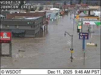
Live Webcams
Webcams on Highway 1
Webcams from all along Highway 1 in the Fraser Valley can be reviewed in real-time on the DriveBC website.
Here is a link to a pre-filtered page that has the most relevant webcams already pulled up.
Webcams in Washington state
Road closures and travel advisory
The Ministry of Transportation issued a travel advisory at 7:15 p.m. Tuesday evening, asking people to avoid unnecessary travel in the Fraser Valley.
Highway 1 and other provincial roadways could close with little or no notice.
Highway 11 at the Sumas border crossing is currently closed to commercial traffic, allowing only local traffic.
Current road closures include:
- Clayburn Road between Highway 11 and Wright Street
- Gladwin Road between King Road and Huntingdon Road
- Bateman Road between Wirght Street and Highway 11
- Boundary Road between Whatcom and Angus Campbell
Road closure information is available in real-time at www.abbotsford.ca/roadclosures.
How to prepare
Residents in evacuation alert areas should prepare to leave on short notice:
- Clear storm drains and gutters of leaves and debris
- Stay away from river and stream banks
- Avoid driving across water-covered roads or bridges
- Prepare a Grab-and-Go kit
- Free sand and sandbags are available at the City of Abbotsford Public Works Yard (31739 King Road). Bring your own shovel.
Reporting flooding issues
If you notice clogged storm drains, localized flooding, flooded roadways, or overflowing ditches, report them by:
- Calling 604-853-5485 during business hours
- Calling 604-864-5552 after hours
- Using the Abbotsford app
Background
The current situation follows extensive coordination with the Province of BC and Whatcom County in Washington State.
The Nooksack River has overtopped its banks, and overflow water takes approximately seven hours to reach the Canadian border based on past events.
The City of Abbotsford's Emergency Operations Centre continues monitoring river levels, dikes, and road conditions around the clock. City staff are stationed 24/7 at Barrowtown Pump Station and throughout the community.
The BC River Forecast Centre issued a Flood Warning for the Fraser Valley as heavy rainfall continues throughout the region.
Where to get updates
The City of Abbotsford will provide ongoing updates at:
- www.abbotsford.ca
- City of Abbotsford social media channels
- www.abbotsford.ca/roadclosures for road closure information
- Follow Tyler Olsen on Bluesky
For more information on heavy rainfall preparedness, visit abbotsford.ca/weather/heavy-rainfall.
Again, if you know anyone in the Sumas Prairie area, please reach out to make sure they're aware of the evacuation orders and offer whatever support you can provide.